


Home > What we do > Aviation > Aviation Meteorological Services


The Aviation Meteorological Office (AMO) aims to provide aviation weather services to contribute to safety improvement, regularity, and efficiency of air navigation. It conducts aviation weather services according to the technical provisions of the International Civil Aviation Organization (ICAO), Annex 3 and the World Meteorological Organization (WMO), as well as standards and recommended practices of regional agreements and conventions in air navigation.AMO, located at Incheon International Airport, generally manages Korea’s national aeronautical meteorology services. AMO operates an airport weather office at each airport in Gimpo, Jeju, Ulsan, Muan, and Gimhae, and an airport weather office at each airport of Yeosu, and Yangyang. AMO issues aeronautical meteorological observation information, aeronautical meteorological forecast and warning, as well as the SIGnificant METeorological information (SIGMET). In addition, it provides airlines and related agencies with worldwide aviation weather information that has been collected via the Aeronautical Fixed Telecommunications Network (AFTN).

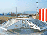
Aeronautical Meteorological Observation services are automated. These services include the observation of wind direction, wind speed, the Runway Visual Range (RVR), temperature, air pressure, precipitation, etc, after setting the Aerodrome Meteorological Observation System (AMOS), in each civil airport and region-controlled airport across the nation.
The agency analyzes aviation observation elements and then conducts various observation activities, such as METAR, local MET Report, SPECI, and local SPECIAL in order to produce and provide weather information necessary for flight safety.

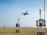
Based on aviation weather observation data, various numerical forecast data, and international preliminary data about aircraft received by the WAFS, the AMO produces and provides TAF, landing and take-off forecasts, area forecast for FL100-250 SIGWX and SFC-FL100 SIGWX Forecasts, SIGMET, AIRMET etc., all of which are necessary for safe aircraft operation. TAF, area forecast for low-level flight, SIGWX Forecasts are issued four times a day, landing forecasts every half hour, and take-off forecasts every hour.

The AMO issues aeronautical meteorology special reports concerning meteorological conditions that may affect flights on the ground, airport facilities, airport services, and safe flight services on the runway. The types of special reports are as follows:
| Type | Contents |
|---|---|
| Aerodrome Warning | Issued when a weather phenomenon that may adversely affect aircraft on the ground, including parked aricraft, aerodrome facilities and services is observed or predicted |
| Wind shear Warning | Issued when the observed or expected existence of wind shear could adversely affect aircraft on the approach path or take-off path or during circling approach between runway level and 500 m (1600 ft) above that level and aircraft on the runway during the landing roll or take-off run |
| SIGMET info | Issued when specified en-route weather phenomena that may affect the safety of aircraft operation in the flight information region(FIR) is observed or predicted-Thunder and lightning, Typhoon, warm currents, ice, etc. |
| AIRMET info | Issued when specified en-route weather phenomena that may affect the safety of low-level flights below 10,000ft is observed or predicted |

The AMO issues aeronautical meteorology special reports concerning meteorological conditions that may affectflights on the ground, airport facilities, airport services, and safe flight services on the airway. The types of special reports are as follows:
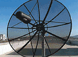
World Area Forecast System (WAFS) : WAFS receives major meteorological forecasts by air altitude, upper wind, and temperature forecasts in a digital format and meteorological data from around 2400 airports in a character/number format provided by the World Area Forecast Center via internet. It then provides necessary meteorological information for the safety of international airlines services.
Global Aviation Meteorological supporting Service : A membership-only homepage service designed to support aeronautical meteorology for domestic and international airline services. It provides scheduled airlines, such as Korea Airlines, Asiana Airlines, and foreign airlines with important meteorological information.
Low-level Aviation Meteorological Information portal : A membership-only homepage service designed to support aeronautical meteorology for domestic and low-altitude nonscheduled airlines services. It provides the Korea Coast Guard, the National 119 Rescue Services, and nonscheduled airlines with important meteorological information.
Airport Control Weather Information System (ACWIS) : An Internet system that can monitor, in real-time, weather conditions of an aerodome and approach control, which is necessary for area traffic control.
![]()
DAEJEON : GOVERNMENT COMPLEX-DAEJEON BLDG 1 11~14F, 189 CHEONGSA-RO, SEO-GU, DAEJEON,
REPUBLIC OF KOREA
SEOUL : 61 16-GIL, YEOUIDAEBANG-RO, DONGJAK-GU, SEOUL, REPUBLIC OF KOREA
Copyright(c) 2022 KMA all rights reserved. E-mail : master_kma@kma.go.kr